News

17th November 2025

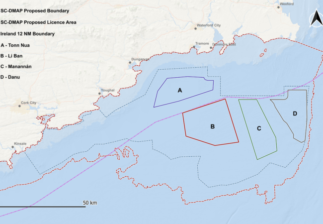
The South Coast Designated Maritime Area Plan (SC-DMAP) of the Northern Celtic Sea is Ireland’s first marine spatial plan for offshore renewable energy. It adopts a plan-led approach and identifies four development sites which will contribute towards the government’s ambition to deliver 5 GW of installed offshore wind capacity by 2030.
Gavin and Doherty Geosolutions (GDG), a Venterra Group company, worked alongside BVG Associates, to support the identification of optimal areas for development within the SC-DMAP.
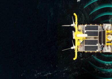
Tonn Nua is one of four Department of Climate, Energy and Environment (DCEE)-designated maritime areas in the region. Located off County Waterford, it is currently in the auction phase, ORESS 2.1, with bidding submissions closing on 20 November 2025. The site is anticipated to support 900 MW of offshore wind energy and is scheduled for completion in the early 2030s.
Our ground modelling team was commissioned by several developers in the region to provide desktop studies and ground modelling for Tonn Nua throughout the multiple stages of DCEE geophysical data release. This work has provided critical insights to support and de-risk auction participation.
Our studies combined academic and publicly available datasets (from our collaborations with Irish universities and public sources – e.g. INFOMAR, British Geological Society), with governmental data released by DCEE which included several geophysical survey datasets and, most recently, geotechnical data. Following each release, we carried out updated interpretation of the seabed and subsurface to ensure a thorough and seamless integration of all available data.
Using newly released geotechnical data, we correlated interpreted geological units with geotechnical parameters and developed a soil zonation model of the entire site. We also identified and analysed hazards and geohazards along with areas of outstanding uncertainty.
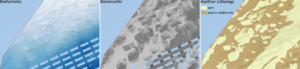
The seabed at Tonn Nua is mainly covered by coarse sediments with isolated areas of sand. Distinctivefeatures such as sand waves (Figure 2), sediment ridges, and eskers (associated with the latest ice sheet advance in the region) were mapped across the site.
In the subsurface, several units were separated representing the bedrock and Quaternary sedimentary cover (Figure 3). The bedrock was interpreted as predominantly Palaeozoic in age and consisting of a series of lithologies. Limestone was the main rock lithology interpreted based on the available borehole data and literature with additional mudstone and sandstone domains delineated in the northwestern and eastern parts of the site. A sliver of Palaeogene limestone/sandstone was also interpreted along the southern boundary of the site.
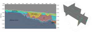
Glacial sediments were interpreted directly on top of the Palaeogene to Palaeozoic bedrock, notably including thick till deposits, comprising high to ultra-high strength clays and dense to very dense sands. Overlying these older units, lacustrine to outwash plain (medium to very high strength / medium to very dense) and subglacial or proglacial fluvial (low strength) deposits were interpreted. A veneer of Holocene marine sands and gravels was inferred across the site based on literature.
Several geohazards were identified within the site, including shallow bedrock, boulders, coarse sediments, over-consolidated deposits, and buried channels. Due to the risks that these elements pose to foundations and cables, each hazard was assessed and mitigation actions proposed. These will form the main inputs for future risk analyses to establish the risk levels at the site.
Man-made obstructions, such as shipwrecks, marine traffic and fishing grounds, were also collated and discussed and recommendations were provided for minimising their impact on project development.
The findings informed a suite of recommendations for additional studies and surveys required to further de-risk the area and support the client during the future development process.
The results of our studies were compiled into interactive 3D ground models enabling an effortless visualisation of the seabed and subsurface conditions and supporting the safe siting of turbines, infrastructure, and cable corridors (Figure 4).
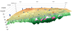
The ground modelling work we carried out for Tonn Nua has provided a robust geological framework crucial for risk assessment and design and enables data-driven decision-making.
Tonn Nua is one of several Celtic Sea sites for which we have delivered extensive ground modelling work. Our experience also spans the Lí Ban, Manannán, and Danu sites auctions, with preliminary interpretations already completed for Lí Ban.
Through our access to additional academic data for the region, deep knowledge of local ground conditions and extensive experience in survey design and management, we are strongly positioned to support future geophysical and geotechnical campaigns, provide data reviews, and undertake updated integrated ground models for the site.
Working in collaboration across the whole Venterra Group, we offer expertise in coastal and marine processes, UXO, and risk management. Our work in ground modelling naturally bridges to the engineering design services offered by our Design team, providing a fully integrated service offering across the lifecycle of offshore wind projects.
Read the full GDG/BVG SC-DMAP area report here.
17th November 2025
22nd October 2025
20th October 2025